
Making Waves
MAFES researchers help coastal systems thrive
By: Vanessa Beeson
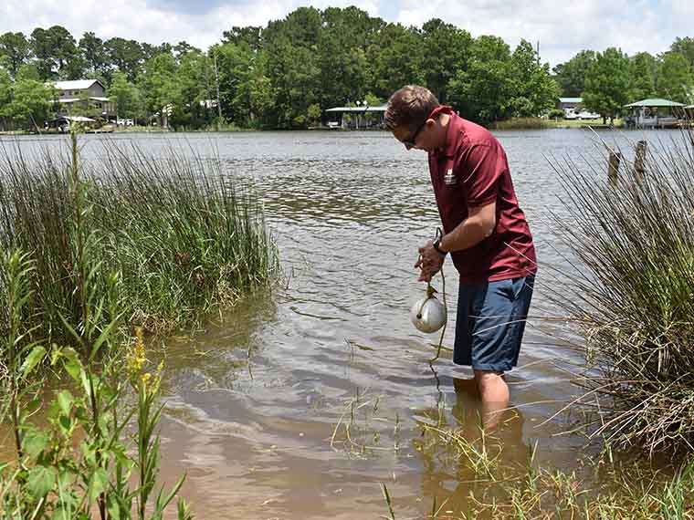
Nigel Temple deploys a sensor in Fish River in Fairhope, Alabama. Temple built this sensor and others like it, which MAFES researchers will use to map the wave system in the Back Bay of Biloxi, Mississippi. (Photo by Sarah Cunningham)
The information presented on this page may be dated. It may refer to situations which have changed or people who are no longer affiliated with the university. It is archived as part of Mississippi State University's history.
Dr. Anna Linhoss-who grew up harvesting oysters from the Chesapeake Bay-became a hydrologist because of her love of the ocean.
"Growing up, we'd walk a quarter mile from our house and there would be oysters the size of my shoe. We'd pick up a bushel of oysters and take them home and make oyster stew. It wasn't that big of a deal. It was fun, but it wasn't this precious resource," Linhoss remembered. "The oysters died off in the 1980s and 90s, mostly from disease and pollution. I saw that happen. It's been a part of me."
While the restoration of Chesapeake Bay is underway and there are now oysters back in the waters near Linhoss's childhood home, she's turned her focus to places like the Mississippi Gulf Coast. The MAFES scientist and assistant professor in the Department of Agricultural and Biological Engineering is studying better ways to measure waves in order to build improved models for understanding dynamic coastal systems.
Linhoss, who is also assistant director of the Geosystems Research Institute, has partnered with Dr. Eric Sparks, assistant extension professor at the Coastal Research and Extension Center and coastal ecology specialist for the Mississippi-Alabama Sea Grant Consortium, and Nigel Temple, a doctoral student in the Department of Wildlife, Fisheries and Aquaculture in the College of Forest Resources, to investigate the wave energy of the Back Bay of Biloxi and surrounding tributaries. Sparks and Temple have built and validated inexpensive wave gauges while Linhoss has created models that utilize those gauges.
Commercial wave gauges measure amplitude, height, and frequency, which tell scientists how much energy a wave has, how fast it can go, and how much erosional force it has, among other things. These gauges come with a steep price tag, however, which makes using several gauges at once difficult to justify for most research budgets.
Linhoss said more gauges can help create enhanced models, which will better predict things like coastal erosion over time.
"Right now, commercial wave gauges range from $1,500 to $30,000, which is very expensive," Linhoss said. "If you want to measure waves in any particular area, you can set out a few but not 20."
Sparks and Temple were working on a different project when they discovered a need for less expensive gauges.
"We were interested in how well different restoration projects removed nutrients from the marsh," Temple said. "Our research sites were getting hammered with boat traffic and we realized understanding the wave action was a critical first step."
The team knew they'd need a large number of gauges to understand how both wind and wakes impacted the wave climate so with a Special Research Initiative grant through MAFES, they built two types of gauges. The first gauge, which rests on the seabed floor, houses a sensor that measures total pressure (which is calculated by adding hydrostatic and atmospheric pressure) along with a microcomputer to collect the data. The second gauge houses an acoustic sensor and microcomputer and is attached to an existing marine structure and rests up to two meters above the water. So far, they've made 60 pressure gauges and 25 acoustic gauges.
"The ultrasonic sensors in the acoustic-based gauge measure the distance from the sensor to the water surface, so distance decreases with wave crests. The pressure sensors on pressure gauges essentially measure the inverse-where pressure increases as the wave crests." Temple said.
The team then tested the gauges in a wave flume laboratory at the University of South Alabama and both sensors worked well. When they tested the gauges in the field, however, Temple said that while the pressure sensors worked great, the acoustic sensors were too sensitive for what the researchers were trying to accomplish.
"The pressure gauge delivers high frequency data comparable to the commercial gauges so it's reliable for measuring wave events," Temple said. "The acoustic sensors were too sensitive to sound and environmental noise to measure waves accurately, but they are useful for tracking water levels in general so they're great for things like studying tidal inundation caused by sea level rise."
The team plans to launch 45 pressure gauges in the Back Bay of Biloxi in summer 2019, to verify their efficacy through modeling, and then will explore how the waves impact shoreline vegetation. Thus far, they've accomplished the goal of building a lower cost wave pressure gauge.
"Commercial gauges that deliver this kind of data are around $3,000. Our gauges cost between $250 to $270 to build so you can get 10 for the price of one," Temple said, who pointed out the lower price point makes it less painful to conduct studies in inclement weather. "We used the gauges to capture data during Tropical Storm Gordon, and while we lost two of them, the loss was around $600 instead of $6,000."
Temple said the overall goal is finding more cost-effective strategies for coastal restoration.
"Ultimately, improving coastal restoration is the goal. One of the main drivers of restoration design is the wave climate. If you don't take the waves into consideration, you are at risk of the restoration project failing all together or being inadequate in a certain setting," he said. "This kind of information will help agencies like the Mississippi Department of Marine Resources complete more effective coastal restoration projects at a lower cost."
Linhoss said that the project will help scientists better understand how to protect coastal systems.
"This opens up a whole opportunity where you can make maps of the entire wave environment instead of just relying on a few data points, so you can really understand the system better," she said. "This work is another vital step in helping build and maintain both a sustainable coastal human community and a sustainable environmental community."
Bret Webb, civil and coastal engineering professor at the University of South Alabama, and Just Cebrian, associate director of the Northern Gulf Institute, contributed to this research. Undergraduate wildlife, fisheries and aquaculture students involved include Haley Moss, Matthew Virden, and Andrew Lucore.
This research opens up a whole opportunity where you can make maps of the entire wave environment instead of just relying on a few data points, so you can really understand the system better.
Dr. Anna Linhoss
Behind the Science
Anna Linhoss
Associate Professor and Assistant Director of Geosystems Research Institute
Education: B.A., Anthropology, University of Colorado; M.S., Agricultural and Biological Engineering, University of Georgia; Ph.D., Agricultural and Biological Engineering; University of Florida
Years At MSU: 6
Focus: Hydrologic and ecological modeling
Passion At Work: I am interested in understanding the interactions between water and the environment and how humans impact those interactions. I am particularly interested in modeling coastal and freshwater systems to identify sustainable and resilient management solutions that meet human needs without detrimentally impacting environmental systems.