
Forage Flyover
Using UAVs to determine forage quality
By: Taylor Vollin
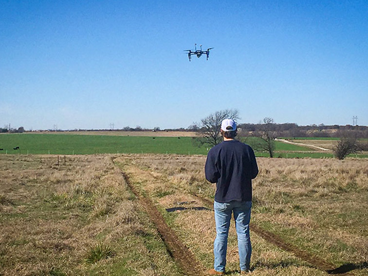
A student flies a drone over a grazing pasture to record the amount of light reflected in key wavelengths associated with plant health characteristics. (Photo submitted)
The information presented on this page may be dated. It may refer to situations which have changed or people who are no longer affiliated with the university. It is archived as part of Mississippi State University's history.
From disaster relief to recreation to agriculture, unmanned aerial vehicles (UAVs), or drones, have become widely used across the globe. In the U.S. there are 865,607 drones registered with the Federal Aviation Administration (FAA) with 35 percent enrolled for commercial purposes.
As a FAA Center of Excellence for Unmanned Aircraft Systems, Mississippi State University is a leader in the use of drones in agricultural systems. The use of drones with other data provides scientists with a wealth of information. That is why MAFES scientists are taking an aerial view along with tracking movement data to measure cattle grazing efforts.
Dr. Garrett Street, an associate professor in the Department of Wildlife, Fisheries and Aquaculture, co-director of the Quantitative Ecology and Spatial Technologies Laboratory, and scientist in MAFES and the MSU Forest and Wildlife Research Center, leads a team focused on using UAVs and accelerometers to better understand forages. Specifically, the research aims to learn how forage quality and availability influence the long-term body quality and behavior of grazing animals, such as cattle, while remaining cost effective.
"We are working to develop mathematical models that will allow us to think about how cattle behavior and movements affect calorie intake and expenditure," Street explained. "We can then think about how their behaviors, patterns, and metabolic demands all influence the amount of body mass they gain. In order to do that, we need an accurate picture of what food is available and the quality of that food."
The project has been in the works since 2019, giving enough time for the team to start producing models. So far, Street has been able to create models predicting forage characteristics like total fiber, crude protein, and nitrogen. Street said they have also been able to produce maps giving fine-scale and accurate information about different aspects of forage quality that affect grazing systems.
"While we can't estimate all aspects of forage quality because some components are unpredictable, we can assess many of them," Street added. "This gives us hope that we can produce these models for almost anywhere so long as we have some time and effort to collect the field data."
The team has used different methods to collect the data. They have gone into the field to clip plant biomass to run analyses to quantify crude protein, fiber, and nitrogen. They have flown drones over the same space to determine the amount of light reflected in key wavelengths associated with plant health characteristics. Combining the ground data and the drone images allows scientists to create models describing the quantity of each nutritional component present.
Researchers also attached accelerometers around the necks of cattle to determine how much time they spend grazing and where.
By pairing the traditional boots-on-the-ground approach and remote-sensing technologies, Street said they can get a fuller landscape image of the quantity and quality of food, as well as how cattle use the landscape.
"Using only a boots-on-the-ground method means you're just collecting at very specific locations and you don't really have any knowledge about what exists between those locations," Street said. "You get gaps in the map, so what we're trying to do is bridge that gap; let's use the ground data and get the raw information, but also use the drones to get fine-scale information about the whole space and relate those to one another."
Dr. Joby Czarnecki, an associate research professor in the MSU Geosystems Research Institute and MAFES scientist, provided her UAV expertise for the project.
"Remote-sensing is determining attributes of an object without destructively sampling it," Czarnecki said. "We like this idea of remote sensing because it allows us to infinitely sample from an area without paying a per-unit sample cost and, in theory, get more contextual data from the entire area."
While UAVs offer great assistance in covering more land, Czarnecki notes how important it is to still collect on-the-ground data.
"It's great to have a picture, but if you don't know what it actually relates to on the ground then it shows you the variability, but it won't show you your actual situation," Czarnecki explained. "You need the ground data to understand what the red and green in the images actually correlate to in the field. That's where the boots-on-the-ground comes in. We need the ground data to generate prescriptive recommendations to land managers."
By determining what an ideal situation looks like through UAVs, Czarnecki hopes satellites can then be used to broaden the scale of the technology.
"We can then start to think about what that looks like on a global scale. What's the global forage quality? It would be nice to get to at least a regional scale so every landowner doesn't need their own UAV," Czarnecki said. "They have access to some of these satellite-based products, so if we can make the relationship with something that is freely available and easy to use, then we've made a tool that's affordable and accessible. That type of outcome is great for landowners."
The products produced from this research will allow cattle producers to know how much forage is available in a pasture as well as the nutritional quality of that forage, decreasing the likelihood of overgrazing.
Collaborators include Noble Research Institute in Ardmore, Oklahoma. This research was funded by the USDA, the AFRI Foundational and Applied Science Program, and MAFES.